Nisei Ski Club Presents a Hike in Alum Rock Park, San Jose, CA – Saturday, August 27, 2016
David Schultz
Due to its location, Alum Rock Park is kind of a secret to many people who live in the Bay Area. While other parks like Mission Peak may be full of hikers, the trails at Alum Rock Park are largely empty.
Located in the upper East side of San Jose, Alum Rock Park encompasses over 700 acres of rugged canyon terrain, with each side of the canyon presenting a different ecosystem. On the shady side, the forests are thicker and taller and on the sunny side, the foliage is more bushes than trees, with sweeping areas of dry grassland. Sage is one of the most common plants in the park and the air typically smells of this fragrant bush.
The Hike
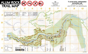
I’ve put together a loop hike based on the South Rim Trail. It’s a good overall length (7.5 miles), is on the shady side of the canyon, climbs about 700 feet so it provides good exercise, and offers excellent views of the park and Santa Clara Valley in the distance. In addition, you pass all of the Alum Rock Park tourist attractions on the way back to the beginning, including the Mineral Springs area which contains active sulfur springs and grottos, Youth Science Institute, and the park ranger station (which is part museum). We’ll have time to stop at these attractions.
The hike will be done at a moderate pace and will take approximately 4 hours, including our stops. If we’re lucky, there’s a chance that we’ll spot some wildlife, including deer, rabbits, fox, bobcats, wild turkeys, quail, and possibly a rattlesnake. (Don’t worry – I’ve only seen a rattlesnake once in over 10 years of hiking in the park.) Overhead, we’ll probably spot turkey vultures and hawks.
After the hike, people are welcome to lunch at my house. I’ll provide food and drinks, and we can relax and take in the views.
Meeting Point
We will meet at David Schultz’ house at 16100 Yona Vista Avenue, San Jose, CA 95127. There is room in my driveway for about 8 cars, plus there’s plenty of street parking. The park entrance is about 1/4 mile away from my house, so we can avoid parking fees at the park and still be close to the entrance. We’ll meet at 10 AM.
Directions:
Take Route 680 to Alum Rock Avenue. Follow Alum Rock Avenue all the way past the San Jose Country Club, where the road bends to the left. Keep bending around to the left, and as the road straightens out, look for Chula Vista Drive. The street sign will also say “To Yona Vista Avenue”.
Chula Vista Drive twists and turns and goes up and down, but it doesn’t last long. After going down a short steep hill, the road rises and offers a great unobstructed view of San Jose to the left. About 50 feet later, you reach the intersection of Chula Vista Drive and Yona Vista Avenue. My house is on the corner on the right side. It’s a brown house with beige trim, and it has a Japanese style roof. Feel free to park in the driveway if there’s space. Pull up as far as you can since we’ll pack the cars in.
What to Bring
There are no drinking fountains until the last mile of the hike, so bring plenty of Gatorade or a similar electrolyte drink. Water is okay, but since you may sweat a lot if the weather is warm, an electrolyte drink is better for replacing lost salts. I recommend at least two quarts of liquid to cover you over the 6 miles of dry trail.
In addition, the following items are recommended:
- Wide brimmed hat for sun protection
- Sunglasses
- Sunscreen (at least SPF 15)
- Snacks for the trail and lunch if you need it earlier than lunch at my house
- Lightweight hiking shoes. The trail is mostly packed dirt, but there will be some loose rocks occasionally. So hiking shoes will be better than running shoes or sneakers
- Jacket in case of cooler weather
Hiking Details
- From 16100 Yona Vista Avenue, we’ll walk 1/2 mile along Yona Vista and Canon Vista avenues to the park entrance at the end of Alum Rock Avenue
- After entering the park, we’ll make a quick left onto the Stables Trail.
- The Stables Trail takes us another .4 mile down to the Penitencia Creek Trail. This is the main trail through the lower part of the park. We make a right onto the trail.
- Walking along the Penitencia Creek Trail, we’ll cross a bridge over Penitencia Creek, cross over Penitencia Creek Road (the main road through Alum Rock Park), and turn right onto an access ramp that takes us to the Peninsular Trail.
- We walk along the historic ramparts of the Peninsula Trail (once part of the Alum Rock Railroad), cross back over Penitencia Creek Road, and take a right onto the North Woodland Trail.
- The North Woodland Trail meanders upwards through a forest of oak, buckeye, and madrone trees. In between them, I’ll point out to everyone the abundant poison oak.
Poison oak exists throughout Alum Rock Park, often in large bushes, and is identified by its classic three-leaf from one stem arrangement, with mildly serrated leaves similar to regular oak trees, and the leaves are shiny (due to the poisonous oil) and often red in color. Poison oak is a natural part of central California and the park service doesn’t do much to contain it. Basically, they clear the trails of it. By exercising a little caution, you won’t have any trouble with this constant companion.
In about .5 mile, the North Woodland Trail brings us to a service road.
- We cross the service road and look on our right for the South Rim Trailhead. Getting on the South Rim Trailhead, we soon start seeing views of the park valley below.
- The South Rim Trail switchbacks along the upper forests of Alum Rock Park. As we near the top of the trail, the foliage becomes shorter and the trail sunnier. And the views get bigger. If the weather is good, we’ll have fine views of the park below and the Santa Clara Valley further out. By mile 3, we have reached the top of the South Rim Trail,
- We begin our descent while still on the South Rim Trail. It switches back and forth along the backside of Alum Rock Park, giving us a good sense of the steepness of the hillside. We reach the bottom of the trail around mile mark 4.5, and we turn onto the Penitencia Creek Trail.
- Right away we come to a beautiful rest area near Penitencia Creek and just before an old foot bridge. We’ll stop and have a snack.
- Crossing over the bridge, we continue on the Penitencia Creek Trail past group picnic areas and various man-made structures to contain the sulfurous mineral springs. We’ll explore some of these structures.
(from Wikipedia)
“In the late 19th century and through the 1930s, the park was famed throughout the country as a health resort. Through those years and as late as the 1970s, the park featured a natatorium (a huge, heated indoor swimming pool), dozens of private heated mineral baths that visitors could rent, a restaurant, and various other buildings. Many of the springs were enclosed in stonework grottos, and stone bridges were built across the creek. Due to overuse, some of the springs became extinct, and surviving ones became very weak, producing very little output.”
- Leaving the mineral springs area, we walk into the “tourist” part of the park and soon come to the Youth Science Institute. We’ll also find bathrooms and water fountains. We’ve now hiked about 6 miles.
The YSI is used for educating Santa Clara County’s youth about ecology and native flora and fauna. It offers summer camps, classes, and has a good museum with both live and taxidermy animals.
- Soon after leaving the YSI, we come to the park’s official ranger station, where another small museum awaits, this one offering more human history than ecology. Nearby is one of the oldest buildings in the park – a log cabin built in 1913.
- The sweet smell of barbecue from the picnickers will probably be our companion as we continue along the Penitencia Creek Trail to the base of the Alum Rock Road entrance. Our total walk is now 7 miles. This part of the road is closed to vehicles, so we can spread out and ascend it to the park entrance where we began.
- Another 1/2 mile brings us back to my home on Yona Vista Avenue.
Contact me
For more information, you can email me at aughike2016@niseiskiclub.org. My contact number is 510-512-6441. Participants can call me if they get lost coming to my house, or while on the hike.
|
Link to trail map